Augmented Reality Roman Leicester App

The AR Roman Leicester App is a location-based virtual reconstruction which seeks to bring some aspects of Roman Leicester (Ratae Corieltauvorum) in the year 210 AD to life through 3D graphics and augmented reality.

It has been developed by De Montfort University in association with Mixed Reality Ltd and with support from Leicester Arts and Museum Service and the University of Leicester Archaeological Services.

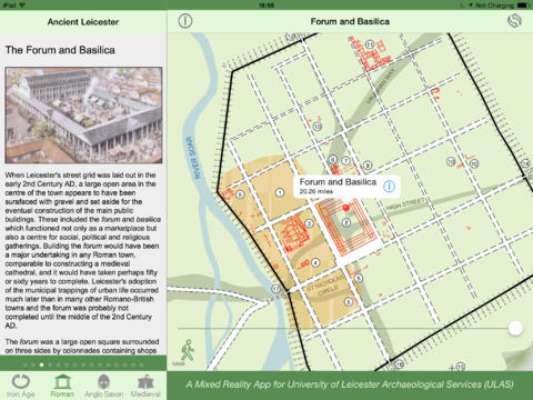
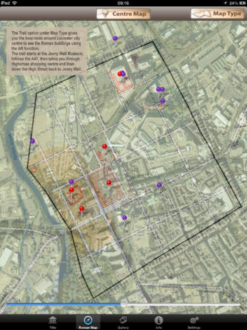
You can view a selection of 3D Roman buildings and artefacts using either the map or gallery page.

Having selected a building or artefact, you can learn more about it, see a Roman ‘brooch’ acting as a compass pointing towards the original ‘find’ location, and view an interactive 3D model.

If you are close enough to the real location, an Augmented Reality view is activated that allows you to see the building or artefact overlaid visually on a camera view of the real world.

Even if you are not near the site in Leicester you can use the Settings tab to select Advanced Settings then move the pointer to wherever you wish to be on the site map.

VRomans3 VRomans4vRomans1     VRomans2

Featured on BBC East Midlands

Error
This video doesn’t exist

Download free iPad App from Apple’s App Store

Visions of Leicester App

This App is based on the book ‘Visions of Ancient Leicester’ by Mathew Morris and Richard Buckley of the University of Leicester Archaeological Services (ULAS). The artist Mike Codd was commissioned to prepare a series of reconstruction drawings of the town and many of its most important buildings for inclusion in the book.

The App is intended as an accompaniment to the book, presenting some of its contents in interactive form.

The App incorporates material from the book consisting of four sections covering Iron Age, Roman, Anglo Saxon and Medieval periods, with descriptions of archaeological sites. There are also four associated archaeological maps graphically superimposed on modern-day Leicester.

The text pages and maps are linked dynamically. Clicking on a map marker, takes you to the relevant description and, from each page of text, clicking on the map icon, displays the associated map.

Although maps are presented for all four eras, the textual descriptions focus on the Roman and Medieval periods about which more is known.

highcross1

The free App is downloadable for iPhone or iPad at Apple’s App Store